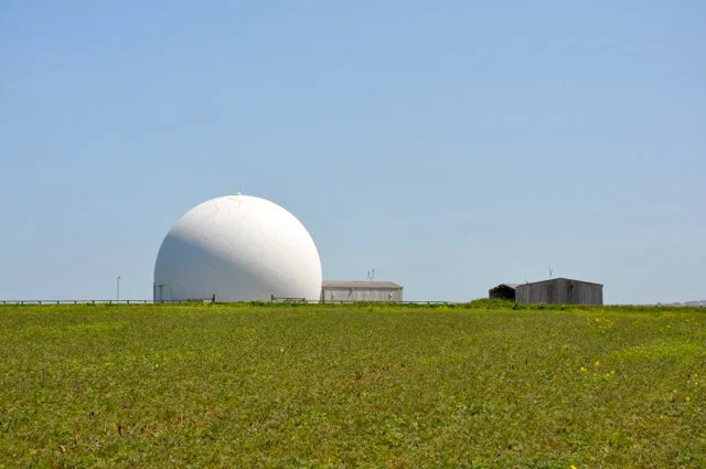
The ‘golf ball’ radar at RRH Portreath
I’ve been fascinated for a while by the mysterious giant golf ball on the coast near Portreath that can be seen for miles around. It was only recently that I passed as near to it as I’ve ever been, when we walked the coast path from Porthtowan to Portreath.
In 1940, a coastal area of fields near Portreath called Nancekuke Common was chosen by the army as the location for a new airbase. Like with other areas taken over by the MOD, including Tyneham in Dorset and Imber in Wiltshire, the farmers who worked the land had very little time to vacate and within a matter of months an airfield, RAF Portreath, was constructed. This had various uses throughout the war, including a fighter command station.
After the war the airfield fell into disuse until 1950 when the site, due to its isolation and proximity to the coast, became an outstation of Porton Down, the controversial military research site in Wiltshire. The top secret Chemical Defence Establishment (CDE) Nancekuke was created to test chemical weapons, in particular the nerve agent sarin. Some twenty tons of the toxic compound was made in the mid-1950s for testing and trials but by 1956 the site stopped production.
Instead it focussed on other chemicals, including CS gas or tear gas, used to control riots. By 1976 operations were winding down and a review recommended to transfer all work to Porton Down. Although most of the chemicals were taken to the Wiltshire site, a substantial amount of chemicals were simply dumped down mine shafts in the area.
The site was handed back to the RAF and became RRH (Remote Radar Head) Portreath, which is what it remains to this day. The large ‘golf ball’ is a fibre glass protective cover for a BAE Commander SL series radar, which works remotely, hence RRH.

Whilst we were walking along the path, I couldn’t help but notice a break in the fence, and couldn’t resist climbing over to get closer to the golf ball. As I walked gingerly over a very exposed field I was aware of remote-controlled planes in the air. I got maybe halfway over the field when a loud air raid-type siren went off. I slowly turned around and crept back over the fence.
Helen thought I was being paranoid and that neither the planes nor the siren were anything to do with me illegally entering an MOD site (we had done it before, after all, and I’ve done it loads of times on my own). I wasn’t so sure. Maybe not the planes (there were amateur enthusiasts in the area) but the siren I thought was some kind of automated sensor. I’ll find out if/when I return.
Walking over the field reminded me of a story I’d heard from a former colleague about the Nancekuke cabbages – I’m sure she’d told me she’d gone to dinner on the site and eaten them for a special event. It didn’t sound healthy to me. But the genus brassica is apparently a thing – local photographer William Arnold has chronicled them in his series Cauliflower Fields (Forever), ‘part of an ongoing body of work with [artist] Robin Dowell [who cast a cauliflower in lead] concerned with the secretive former chemical weapons plant at Nancekuke’. Photographer Michael Crocker has also done a nice series of black and white photos of the area.
In 2000 it was reported that former workers on the then-top secret site had either long-term health problems or died from exposure to nerve gas. There was also concern about contamination in earth and water supplies. The matter was raised in parliament and apparently the Nancekuke Remediation Project, a ten year plan, was launched soon after to decontaminate the land. Still, I’ll pass on the cabbage.
Previously on Barnflakes
• St Agnes to Perranporth coastal walk
• Tanks for the memories
• Abandoned plane graveyard at Predannack Airfield, Cornwall
• Tyneham ghost village
• Straight Outta Imber